Flood events often cause widespread damage to buildings, equipment, and other property. Once flood waters have subsided and an affected site has dried out for days, weeks, or months, it can be a challenge to discern the level to which the flood waters rose. These flood water levels are of concern when assessing a specific site for damages after a flood event, such as when hurricane-induced flooding occurs. Aerial imagery, ground-truth measurements and observations, and forensic meteorology can be used to estimate the height of flood waters at a given location or across an area; but nothing tells the truth like watermarks.
Watermarks are characterized by the limits of staining or remnant debris on building materials (Figure 1). Some of the most readily apparent watermarks often occur on glass surfaces (Figure 2).
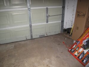
Figure 1. Watermark on a garage door. This was from flooding during Hurricane Harvey.
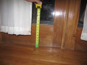
Figure 2. Watermark on the glass of a door. This was from flooding that occurred during Hurricane Katrina.
However, in cases where building materials have been removed or where there are no buildings at all, watermarks or evidence of flood waters can sometimes be discerned on vegetation (Figure 3).
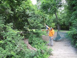
Figure 3. Mud and debris line on vegetation. This was adjacent to a river that flooded.
Finding established watermarks can provide valuable information for a given site and for the surrounding area. Comparison of watermarks in a localized area can establish pre-existing water levels and this information may be used to correlate with a wider data set from a flood event or to determine the water levels at adjacent sites.
Nelson’s team of professionals has evaluated thousands of buildings and building sites for watermarks and other evidence of flooding. For additional information on the use of watermarks in investigations of sites that have experienced flooding, please click HERE to review the technical paper authored by Erik L. Nelson, Ph.D., P.E., which was presented at the 2012 ASCE Congress on Forensic Engineering in San Francisco and was published with the conference proceedings.
Furthermore, Nelson’s team has unique expertise in the development of event-specific Geographic Information System (GIS) models to assimilate data from multiple sources to evaluate the extent and effect of flooding over large land areas. For more information about this, please submit an inquiry HERE.